Gravity Survey
Measures variations in the Earth’s gravitational field to identify changes in subsurface density, supporting geological mapping and detection of density anomalies.

Potential field methods measure natural variations in the Earth’s gravity and magnetic fields to provide insight into subsurface conditions. These methods respond to contrasts in density and magnetic properties, allowing geological structures and features to be interpreted over large areas. As non-invasive techniques, gravity and magnetic surveys are well suited to broad-scale investigations where efficient coverage and regional context are required.
Contact UsPotential methods measure variations in the Earth’s gravity and magnetic fields to identify contrasts in subsurface density and magnetic properties. These contrasts can be used to interpret geological structure, map variability and identify anomalous features. Gravity and magnetic surveys are typically applied where large areas need to be investigated efficiently, or where other methods are limited by access, depth or ground conditions.
Potential field methods are well suited to projects requiring broad-scale subsurface understanding or rapid coverage of large areas. They are typically applied where density or magnetic contrasts are expected, supporting exploration, hazard identification and early-stage site investigation.
The value of potential field methods lies in selecting the appropriate technique and interpreting results in the context of site conditions and project objectives.

Measures variations in the Earth’s gravitational field to identify changes in subsurface density, supporting geological mapping and detection of density anomalies.

A higher resolution gravity technique used for near-surface investigations, including identifying density variations potentially associated with voids or ground instability.
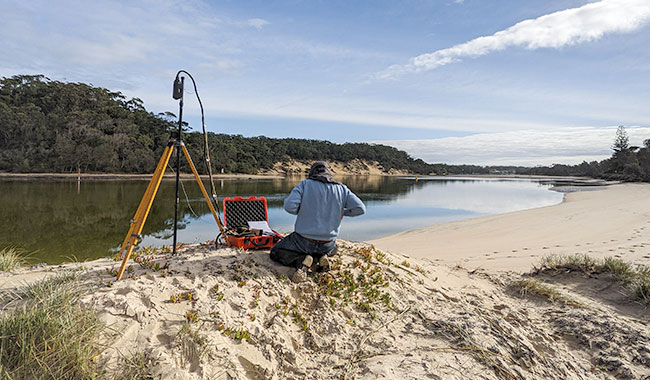
Measures variations in the Earth’s magnetic field to map geological structures and detect buried ferrous objects and infrastructure.
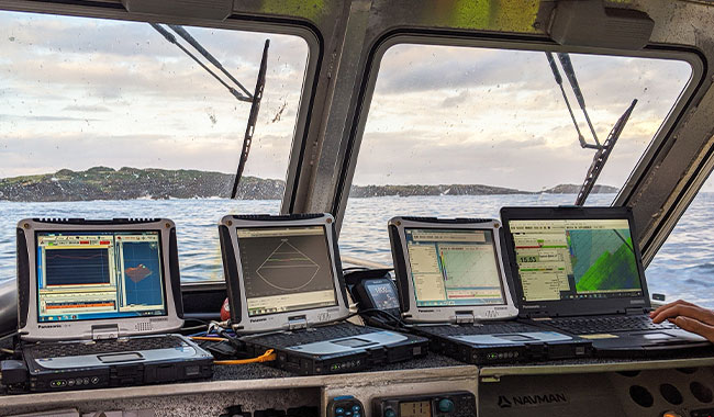
Applied in marine environments to locate metallic objects, support dredging clearance and identify seabed hazards.

Measures magnetic field gradients to enhance detection of shallow targets, commonly used for UXO detection and archaeological investigations.
Geophysical potential field methods, including gravity survey and magnetic survey techniques, measure variations in the Earth’s natural fields to map subsurface features, geological structure and material contrasts.
A gravity survey is used to detect variations in subsurface density, supporting geological mapping, mineral exploration geophysics and, in some settings, void detection geophysics.
A magnetic survey is a geophysical method that measures variations in the Earth’s magnetic field to identify contrasts in magnetic properties. It is used to map geological structures, detect buried ferrous objects and infrastructure, and supports applications including mineral exploration, UXO detection and dredging clearance.
Gravity survey methods respond to variations in subsurface density, while magnetic survey methods respond to contrasts in magnetic properties. Gravity methods are commonly used for geological mapping, density anomaly detection and some void detection geophysics applications, while magnetic methods are often applied to structural mapping, UXO detection geophysics and locating buried ferrous objects. The two methods can be complementary and are often used together to improve interpretation.
Yes. Microgravity survey can help identify density anomalies potentially associated with voids, while magnetometry survey methods are widely used to detect buried ferrous objects and UXO targets.
Geophysical potential field methods provide efficient, non-invasive subsurface mapping by measuring natural variations in gravity and magnetic fields. These methods are particularly valuable where broad-scale geological structure, subsurface variability or density and magnetic contrasts need to be assessed over large areas.
Gravity survey and magnetic survey data are commonly integrated with seismic, drilling and engineering datasets to improve interpretation and reduce uncertainty. When correlated with other site information, these methods can provide important regional context and help refine investigation targeting.
A combination of gravity survey, microgravity survey and magnetometry survey techniques are used depending on site conditions and investigation objectives. Method selection is typically influenced by target depth, expected contrasts, required resolution and survey environment.
Microgravity survey provides high-resolution data for shallow investigations, while broader gravity survey techniques support regional geological mapping. Together, these methods can be applied across scales ranging from near-surface anomaly detection through to broader structural interpretation.
Land and marine magnetometry survey methods provide flexible magnetic survey solutions across terrestrial and marine environments. Applications range from mapping geological structures through to locating buried ferrous hazards and supporting dredging clearance survey investigations.
These methods support mineral exploration geophysics, UXO detection geophysics, void detection geophysics and dredging clearance survey applications across a range of sectors. Their ability to provide efficient coverage over large areas makes them particularly useful in reconnaissance and hazard identification investigations.
Our workflow ensures efficient acquisition and processing of gravity survey and magnetometry survey data, delivering clear and actionable interpretations. Interpretation focuses on relating measured anomalies to geological or engineering features in the context of project objectives.
With extensive experience applying gravity survey and magnetic survey methods across Australia and the broader Asia-Pacific region, we focus on selecting the appropriate technique for the geological setting, project objectives and target characteristics.
Our strength lies not only in data acquisition, but in integrating potential field data with broader geophysical and engineering investigations to deliver practical, reliable interpretations. From regional-scale mapping to high-resolution microgravity and magnetometry surveys, we apply these methods to support informed decision-making and reduce uncertainty in complex project environments.

Our experienced geophysical survey specialists work closely with engineers and project teams to design investigation strategies tailored to site conditions, risk profiles and engineering objectives. Speak directly with a geophysicist to discuss your project.
Please complete the form below and a member of our team will be in touch as soon as possible.
Partnering with industry leaders to strengthen technical capability and project delivery.