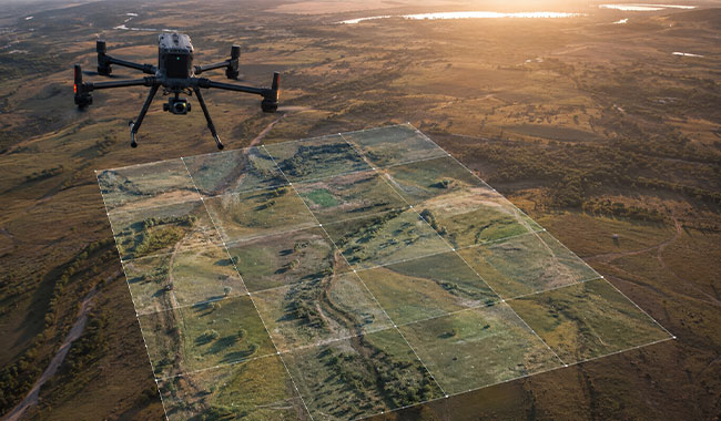
Aerial Photogrammetry
Captures overlapping imagery to generate high-resolution maps and 3D models, supporting orthomosaic mapping and detailed site visualisation.

Drone surveys provide rapid, high-resolution spatial data using remotely piloted aircraft, supporting site mapping, inspection, monitoring and geophysical data acquisition across a wide range of projects.
Contact UsA drone survey, also referred to as a UAV survey, uses remotely piloted aircraft equipped with advanced sensors to capture high-resolution spatial data across a site. Through drone mapping and UAV mapping, imagery and sensor data are processed into accurate geospatial outputs including orthomosaics, elevation models and 3D datasets. Beyond spatial mapping, drone platforms can carry geophysical sensors, extending their capability to include magnetic and electromagnetic data acquisition over areas that are difficult or impractical to access on foot. This makes drone surveys a versatile tool for site characterisation, inspection and monitoring across a wide range of projects.
GBG Group delivers drone survey and aerial survey services across the APAC region, combining spatial data collection with geophysical survey capability.
UAV survey outputs are integrated with geophysical and engineering datasets to accurately constrain surface topography for 2D and 3D data presentation, modelling and interpretation in platforms such as Oasis Montaj and Leapfrog. This integration supports a more complete understanding of site conditions and reduces uncertainty in subsurface interpretation.

Captures overlapping imagery to generate high-resolution maps and 3D models, supporting orthomosaic mapping and detailed site visualisation.

Uses laser scanning to capture high-accuracy elevation data through vegetation and complex terrain, supporting detailed ground modelling and surface constraint for geophysical interpretation.

Mounts a magnetometer sensor on a UAV platform to acquire magnetic data over difficult or inaccessible terrain, suited to detection of broad ferrous targets and geological mapping where ground-based access is limited.

Deploys a drone-mounted EM system for rapid near-surface conductivity mapping, providing efficient coverage across large or constrained areas without the need for ground traverses.
Provides safe and efficient inspection of structures, assets and hard-to-access areas using high-resolution imagery and video capture.
A drone survey or UAV survey uses aerial platforms to collect high-resolution data for mapping, inspection and analysis. It is used across construction, mining, environmental and infrastructure projects, and can also carry geophysical sensors for magnetic or electromagnetic data acquisition as part of a broader site investigation program.
A UAV (Unmanned Aerial Vehicle) survey is an aerial surveying method that uses a remotely piloted or autonomous aircraft equipped with advanced sensors to capture high-resolution spatial data. The data is processed into geospatial outputs such as orthomosaics, elevation models and 3D datasets, supporting site mapping, inspection and monitoring across a wide range of projects.
A LiDAR drone survey uses a UAV equipped with laser scanning technology to collect high-accuracy elevation data across a site. Unlike photogrammetry, LiDAR can often penetrate gaps in vegetation to produce more reliable terrain models than photogrammetry, and can capture detailed ground models over complex terrain, making it well suited to engineering, environmental and geophysical investigations where accurate surface modelling is required.
A UAV survey captures data rapidly over large areas using drone mapping, while traditional survey methods are typically ground-based. Drone survey improves efficiency, coverage and safety, particularly in difficult or hazardous terrain, and enables geophysical sensor deployment where ground access is impractical.
Drone mapping produces outputs including orthomosaics, 3D models, contours and digital surface models. Where geophysical sensors are deployed, processed magnetic or conductivity datasets are also delivered, along with integrated 3D models suitable for interpretation in platforms such as Oasis Montaj and Leapfrog.
Accuracy depends on ground control, equipment and processing methods. When properly executed, UAV mapping can achieve high levels of positional accuracy suitable for engineering, mapping and geophysical integration applications.
We require site location, extent, access constraints, survey objectives and any control or regulatory requirements. For geophysical drone surveys, target depth, sensor selection and flight line spacing are also considered during program design.
Most drone survey projects can be completed within a few hours depending on site size and complexity, with data processing completed shortly after. Geophysical drone surveys follow a similar schedule, with additional time allocated for data processing and interpretation.
GBG combines drone survey capability with in-house geophysical expertise, offering an integrated approach that extends beyond spatial mapping. Whether supporting site characterisation, difficult-access geophysical surveys or 3D subsurface modelling, our drone survey programs are designed around project objectives and delivered with the same technical rigour applied across all our investigation methods.
Drone survey and UAV mapping provide efficient, high-resolution site coverage across a range of environments, from construction sites and mine voids to environmental corridors and infrastructure assets. Using aerial photogrammetry, overlapping imagery is captured and processed into accurate geospatial outputs including orthomosaic maps, digital surface models and 3D datasets suitable for measurement, design and reporting.
LiDAR drone survey extends this capability where vegetation cover or complex terrain limits photogrammetry, using laser scanning to capture high-accuracy elevation data and produce detailed ground models. Together, these aerial survey methods establish an accurate surface model that underpins both spatial deliverables and downstream geophysical data integration.
Surface topography captured through drone mapping is used to accurately constrain geophysical datasets for 2D and 3D presentation and modelling. Integrated workflows in platforms such as Oasis Montaj and Leapfrog allow geophysical results to be visualised in their correct spatial context, improving interpretive confidence and supporting more reliable subsurface models
Drone survey methods support a broad range of project types. Spatial mapping applications include topographic survey, asset inspection, environmental monitoring and construction tracking. Geophysical drone survey applications include ferrous target detection, conductivity mapping and surface-constrained 3D modelling, extending the value of a single mobilisation across multiple investigation objectives.

Our experienced geophysical survey specialists work closely with engineers and project teams to design investigation strategies tailored to site conditions, risk profiles and engineering objectives. Speak directly with a geophysicist to discuss your project.
Please complete the form below and a member of our team will be in touch as soon as possible.
Partnering with industry leaders to strengthen technical capability and project delivery.