August 19, 2026
Borehole Geophysics vs Logging: What’s the Difference?
Explore the differences between borehole geophysics and borehole logging, including key methods, applications and how they support subsurface investigations.
What are Borehole Geophysics and Borehole Logging?
Borehole geophysics encompasses a range of techniques used to obtain geophysical measurements within and between boreholes. These methods were originally developed for exploration in the oil, gas and mineral industries and have since been adapted for geotechnical, hydrogeological and environmental investigations.
Borehole geophysical methods include techniques such as crosshole seismic, vertical seismic profiling (VSP), and tomography, which are used to assess subsurface conditions between boreholes or at depth.
Borehole logging and imaging methods are a subset of borehole geophysics focused on characterising conditions within the borehole itself. These techniques are typically deployed using wireline systems and include tools such as acoustic and optical televiewers, as well as sensors for measuring natural gamma, resistivity, and fluid properties.
In simple terms, borehole geophysics can be used to understand conditions both between boreholes and at depth, while borehole logging provides detailed information within the borehole itself.
What Information Can Each Provide?
Borehole Geophysics
Borehole geophysical methods are primarily used to provide information about subsurface conditions beyond the borehole, helping to build a more continuous understanding of the ground.
Common applications include:
- Seismic velocity measurements at depth, including S-wave velocity for earthquake design and Vs30 assessments
- Identification of voids, large diameter pipes, caverns and mine workings between boreholes
- Assessment of reinforced concrete or steel pile lengths using magnetic methods
- Development of seismic velocity models beneath rivers, road pavements, and other inaccessible areas
These methods are typically applied where drilling alone does not provide sufficient spatial coverage.
Borehole Logging and Imaging
Borehole logging and imaging methods provide detailed, high-resolution information within the borehole itself.
Common applications include:
- Identifying stratigraphic variation
- Mapping bedding, jointing, and faulting
- Supporting hydrogeological and structural assessments
- Characterising material properties through geophysical measurements
These methods provide ground-truth information that complements broader geophysical datasets.
Example Methods for Each
Borehole Geophysics
A range of methods can be deployed depending on the investigation objectives.
- Crosshole seismic measures seismic properties between boreholes using downhole sources and receiver arrays, enabling both direct velocity measurement and tomography imaging

Illustration of Crosshole seismic method
- Surface-to-borehole seismic (VSP) involves generating seismic energy at the surface and recording it within a borehole to assess velocity variation with depth
- Seismic tomography uses multiple ray paths between boreholes to develop detailed velocity models of the subsurface
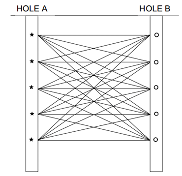
Illustration of Crosshole Seismic Tomography method
- Downhole magnetic gradiometers can be used to assess the length of reinforced concrete or steel piles

Crosshole seismic direct measurement (left) and tomography imaging (right) example results.
Borehole Logging and Imaging
- Acoustic and optical televiewers provide high-resolution images of the borehole wall, allowing detailed structural interpretation
- Natural gamma logging is used to identify lithological variation
- Resistivity logging provides information on material properties and groundwater conditions
- Fluid logging tools measure parameters such as temperature and conductivity
- Full waveform sonic logging provides detailed information on seismic velocities within the borehole

Borehole Logging and Imaging example -Optical and Acoustic Televiewer datasets shown.
Integrating Borehole Methods into Site Investigations
Borehole geophysics and borehole logging are not always used together but can provide a more robust understanding of subsurface conditions when applied in combination. Each method is typically selected based on site constraints, investigation objectives, and the level of detail required.
Borehole logging and imaging are particularly useful for:
- Interpreting structural features such as dipping bedding, joints, and faults
- Situations where core orientation is unreliable or difficult to maintain
- Angled boreholes where traditional core logging is limited
- Developing digital ground models from continuous in-hole records
- Detailed post-drilling characterisation to support interpretation and reporting
Borehole geophysical methods are particularly useful for:
- Achieving greater depth of investigation where surface methods are constrained
- Sites with limited access or restricted working areas
- Providing seismic velocity data at depth for engineering design
- Extending information between boreholes to improve spatial coverage
When used appropriately, these methods extend the value of a drilling programme by providing additional spatial coverage and higher resolution information, helping to reduce uncertainty in subsurface interpretation
GBG Group has extensive experience applying these methods supported by a large pool of specialised downhole equipment available for both consulting projects and equipment hire.
If you would like to learn more about borehole geophysical investigations or discuss your site investigation requirements, please contact our team
More News
View All
4,000+ Projects Across Australia and Asia-Pacific
Our experienced geophysical survey specialists work closely with engineers and project teams to design investigation strategies tailored to site conditions, risk profiles and engineering objectives. Speak directly with a geophysicist to discuss your project.

Contact Us
Please complete the form below and a member of our team will be in touch as soon as possible.